
Bristol UK Postcards
Royal Promenade, Clifton
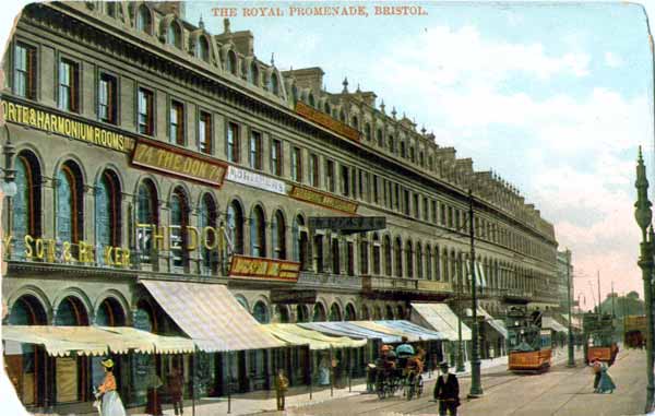
Royal Promenade, Clifton
This postcard with an unreadable post stamp has the printed text...
The Royal Series trademark logo
Max Ettlinger & Co. Ltd., London E.C. and New York
Bristol Series 1096
The Royal Promenade, now Nos. 48-68 Queens Road, was designed by Foster and Wood in the Italianate style and erected 1859-68. Queen's Road itself was only named in 1854.
St. Augustine's Bridge
St. Augustine's Bridge
This unposted postcard has the printed text...
55
"Grosvenor Series"
B.
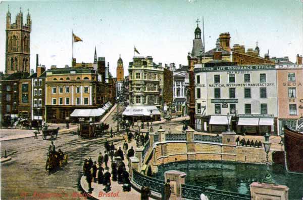
St. Augustine's Bridge
This unposted postcard has just the printed text "Printed in Prussia"
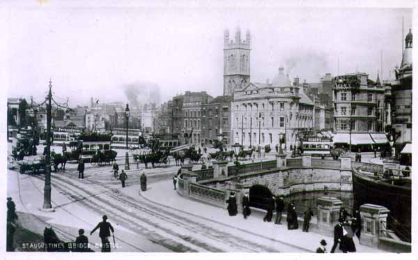
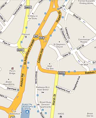
The image shows St. Stephen's church tower on the left, with All Saint's at the end of Corn Street in the middle. The junction of Clare and Baldwin Streets can also be seen. At the time this postcard was produced the harbour stretched as far into the city centre as The Hippodrome, which would have been behind the photographer.
Originally the River Frome joined the River Avon downstream of Bristol Bridge, and formed part of the city defences, but in the thirteenth century the river was diverted through marshland belonging to St Augustine's Abbey (now Bristol Cathedral), as part of major port improvement works. In the late nineteenth and early twentieth centuries, the lower reaches of the Frome were culverted and the river now flows under thr city centre into St Augustine's Reach - the stretch of river seen to the right of the postcard.
At the other end of the city centre, St Augustine's Trench from Stone Bridge to Draw Bridge (near the end of Baldwin Street) was covered over in 1893 and finally the rest of the Trench was covered over in 1938.
As more of the city centre was covered over so the quay has been pushed farther back into St. Augustine's Reach and is now around 500ft further west than shown in the postcard. The following maps should make all of the above a little clearer...
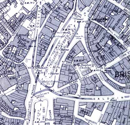
Bristol City Centre from the 1901 Ordnance Survey map and from Google Maps in 2009
St. John's Gate
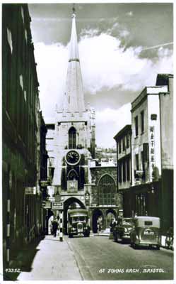
St. John's Arch
This postcard, posted in Bristol on 7th December, 1956, has the printed text...
43352
Printed and Published by Harvey Barton and Son Ltd., Bristol
This is a Real Photograph
The arch is better known as St. John's Gate and is the last surviving gate of the old city walls. The central arch which once contained St John's Conduit is older than the two side arches which were built in the 1820's. St. John's Conduit was built around 1374, by the Carmelite Friars, whose priory was where Colston Hall is now, and carries water from a spring on Brandon Hill.
The tower on St. John's Gate is actually the spire of St. John the Baptist Church which was built on the wall at the end of the 14th Century, when a new outer wall was constructed. The church is also known as St John on the Wall.
The statues of of Brennus and Belinus can just be seen in the postcard picture. According to legend, Brennus was the original founder of Bristol. There is a bit of a problem with these statues though as they both carry crucifixes, but the two kings are supposed to have lived a long time before Christ.
This page created 14th December 2009, last modified 5th March 2010
