Introduction
In July 2024, I received an email from Liz who wanted to know about Weare Street in Bedminster. In 1912, her great grandfather, James Williams, lived at 35 Weare Street, but she could not find the street on any modern map.
While researching Weare Street, I came across references to Weare's Buildings, which on maps on and after 1855, was marked as Weir's Buildings. Many thanks to Geoffrey Bull for identifying where the building actually were so I was able to research them.
Here is everything I know about the street, the buildings and the people who lived in them. If you know more, please email me.
Weare Street
Weare Street ran between and parallel to York Road and Mead Street from Bath Road, near Bristol Bridge to what is now St. Luke's Road.
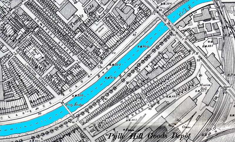
Image: 1902 Ordnance Survey map, Bristol (SE), Gloucestershire Sheet 76.01, reprint by Alan Godfrey Maps
I had thought the street was demolished during the Bedminster slum clearances of the 1930s, see The 1930s Slum Clearance in Bedminster (Bristol and Avon Archaeological Society), but it seems the street survived until the 1970s.
Weare Street contained a pub, the British Queen which was at #53, it closed in 1928. In 1886, the landlord was John Elson; in 1901, S. E. Winter; and in 1914, William S. Avery.
The New Inn stood at the corner of Bath Road and Weare Street. It was demolished to make way for the second Bath Bridge crossing which opened in 1960.
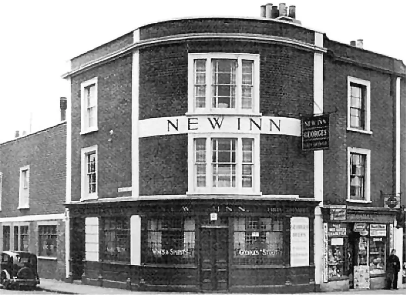
The New Inn which stood at the corner of Bath Road and Weare Street.
The landlords were:
1859 - 72. Charles Iles. In the 1861 census, Charles, 50, lived with his childen Thomas, 19, a beer retailer’s assistant; Edward, 17, a brass founder's apprentice; Henry, 15; William, 11; Kate, 8; and a servant Sarah Shepherd, 18. In the 1871 census, he was living with his wife Jane, 61; and daughters, Jane, 40, Kate, 19.
1874 - 77. Thomas Stoyel
1878. George Flook
1879. Thomas Stoyel
1881 - 82. Frederick W. Jeffery. In the 1881 census, Frederick, 42, was living with his wife Elizabeth S., 35. Living with them was the inn's partner Rebecca Pitt, 44.
1887 - 99. William Hawkins. In the 1891 census, William was aged 50 and a widower. He lived with his daughter Eliza, 28, and niece and barmaid Ada Harris, 17.
1900. Ernest Palmer
1901 - 04. Albert Camfield. In the 1901 census, Albert was aged 39, and living with his wife Analetta, 39, and children Florence, 12; Annie, 7; and Albert, 1. Also living with them was his nephew, Henry Fry, 24.
1906. Edward Buck
1909. William Adams
1914 - 25. Florence Cook
1928 - 31. John Parfitt
1934 - 50. Frank Ricks
1953 - 56. Ernest Taylor
Development of the Area
The city council website has a marvellous set of maps and information for almost every part of the city. Much of the following information comes from those.
The 1750 Rocque map shows the area to be completely undeveloped, with just a few trees but mostly scrubland.
The 1828 Ashmead maps shows a few buildings have appeared along what is today York Road, but which was then known as Redcliffe Crescent, with the end nearest Bath Road known as Somerset Terrace. A Rope Walk has appeared near the site of the future Mead Street. What later became Bath Bridge was originally called Hill's Bridge.
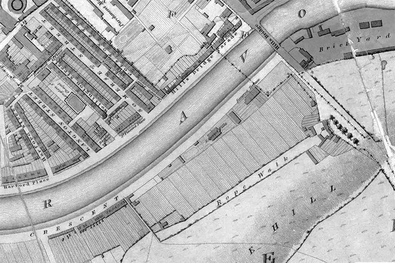
The Mead Street area from the 1880 map
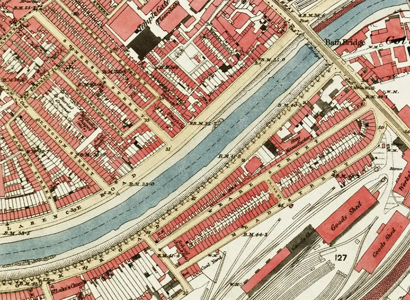
The 1855 Ashmead map shows the Bristol & Exeter railway line and goods yard had been built just south of the Rope Walk at the bottom of Pylle Hill.
The 1874 Ashmead map shows the area fully developed with houses, Weare Street and Mead Street had been built and the area looks much like the 1902 Ordnance Survey map above.
The 1880 map shows that Redcliffe Crescent has now been renamed York Road and that Hill's Bridge is now Bath Bridge. It was difficult to see on earlier maps, but this map clearly shows Messrs. Chappell and Humphries stay factory on the north side of Weare Street.
The Mead Street area from the 1880 map
![]() I was surprised to find a reference to a company in connection with Weare Street. In the Supplement to the New Zealand Gazette of Thursday, May 11, 1899 there is a trademark application made on December 10, 1898, by Chappell, Allen and Co. Limited of 34 Weare Street, Bristol. they describe themselves at Wholesale Manufacturers of Corsets and Underclothing. Their factory was at Avondale Road, Barton Hill. The logo trademark applied for is to the left. They were operating as Messrs. Chappell and Humphries when Bristol and its Environs by the British Association for the Advancement of Science was written in 1875.
I was surprised to find a reference to a company in connection with Weare Street. In the Supplement to the New Zealand Gazette of Thursday, May 11, 1899 there is a trademark application made on December 10, 1898, by Chappell, Allen and Co. Limited of 34 Weare Street, Bristol. they describe themselves at Wholesale Manufacturers of Corsets and Underclothing. Their factory was at Avondale Road, Barton Hill. The logo trademark applied for is to the left. They were operating as Messrs. Chappell and Humphries when Bristol and its Environs by the British Association for the Advancement of Science was written in 1875.
Laurence Cowen, writing as Lesser Columbus, visited the premises in 1893, and wrote about it in his book Greater Bristol.
After the 1960s, the entire area was redeveloped, all the housing was demolished and replaced by industrial units. For example, York Road Service Station is now on the site of 42, 44, 46, and 48 Weare Street.
The Residents
The next three photos were taken from the Bristol City Council map site and are on the Community layer. The photos were very kindly uploaded by Raymond Brunt.
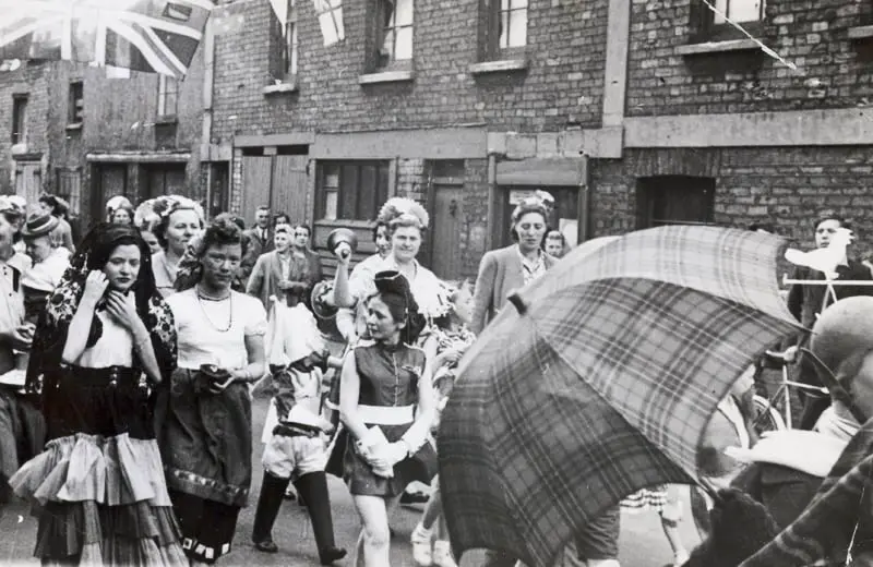
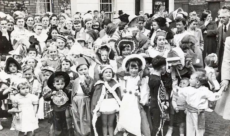
Above and below: Weare Street Parade, possibly for the Coronation, 1953
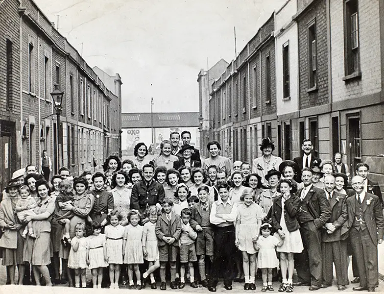
Mr. Brunts family at a wedding celebration in Weare Street
Some of the residents were curriers. A currier is a specialist in the leather-processing trade. After the tanning process, the currier applies techniques of dressing, finishing and colouring to a tanned hide to make it strong, flexible and waterproof.
Primrose, at #1 in 1940. Primrose died in 1940
Edward A. Rickards, at #7 in 1938
Richard Fenton and Olive Elizabeth Mary Fenton, at #9 in 1943. Richard died in 1943 and Olive in 1946
Wallis John Winter, at #10 in 1914
George Edwin & Agnes (Ascott) Phillips at #14 in 1899. Their son Frank was born there on May 3,1899,
Jonas and Mary Harper, at #15 in 1891. They lived with a daughter, Louisa.
John & Sarah (Dawe) Wheaton, at #16 in 1871. John was born circa 1838 in Devon. He married Sarah Dawe there in 1864. They lived with theire children Albert John Tom, Alfred Isaac, and Walter. Sarah was born circa 1841 in Exeter, Devon, and died in 1910. John died in 1927.
Edward Miller, at #16 in 1914
James & Hannah (Kiley) Nutt, at #21 in 1911. Some time around 1915, they had moved to #15 in the street. They had two children, James and Gladys Violet. Both children had trouble with the law, especially Gladys. You can read more about the family on The Criminal Activities of Gladys Violet Nutt (1907) Bristol
John Shellard, at #23 in 1887. John was a plumber, born in 1863, so would have been aged 23.
On 11th July 1887, John Shellard married Georgina Sheppard, aged 18, a servant at Bedford Villas, Portland Rd, Bath. John Shellards parents were Thomas Shellard, born 1838 (coachman) and Ellen Shellard (nee Cross) of Fosscott, Grittleton, Wiltshire. Georgina's parents were Alfred Sheppard (gardener) and Mary Ann Sheppard. In 1871 they were living at Hatt Cottage, Box.
On 7th Sept 1887, Georgina Shellard gives birth to a daughter, Annie Florence. By now they are living at 19 Weare St, Bristol. John Shellard is described as a house painter. By February 1890 John, Georgina and their daughter are back living at 23 Weare St, Bristol, sharing the house with Frederick Melish and his family.
John died on either the 14th or 15th of February 1890, at Bristol General Hospital aged approx 27, from spinal disease psoas abscess which we think is TB of the spine. Georgina was present at his death. John Shellard was buried in Arnos Vale Cemetery on 23rd February 1890.
Georgina then marries John's younger brother Charles (porter/packer) on 6th December 1890, and they return to living at 23 Weare St.
In 1901 the family has grown to 5 children (Annie, William, Arthur Victor, & Helen/Ellen - a sixth child, Elsie Agnes died in infancy) and they are living at 7 Weare St. Charles is now a coachman. They moved to 19 Walter St, Bedminster on or before 1904 when my grandmother, Winifred, was born.
Charles Shellard left the marriage sometime before 1911. Georgina caught influenza in the late 1920's and was brain damaged, living in a semi-comatose state and nursed by her youngest child, Winifred, at home at 136 St Johns Lane, Bedminster until she dies in October 1932, aged 67. She was interred with her first husband, John, in Arnos Vale Cemetery, on 2nd November 1932.
Joseph Marks, at #31 in 1891. Marks was 69 and a general labourer and had a wife, Sarah who was 72. Also registered at the address was his son, Thomas John Marks, aged 34, his wife, aged 31, and Tom, aged 5 months. Thomas John was a potter
James Williams, at #35 in 1912
Genealogists have put together something about the lives of Alfred Oliver, born around 1834, and his wife Sarah Jane (Latham), who was born in 1832, on WikiTree. They were married on December 26, 1857, at St Stephen's in Bristol. They had 12 children, unfortunately, three of them died in the first year of life. The family lived variously at Charlotte Street and Windmill Hill before moving in to #37 Weare Strret. Later they moved to #75 in the same street. Sarah died in 1905 and Alfred in 1914.
Alfred Oliver (age 36, Currier) lived at 37 Weare Street in 1871 with his wife Sarah (37) and six children: Jessie (11, Scholar), Albert (9, Scholar), Minnie (7, Scholar), Florence (6), William (4), and Emily (1)
Alfred Oliver (age 54, Currier) lived at 75 Weare Street in 1891, with his wife Sarah (56) and four children: William (23, Shoemaker Finisher), Emily (21, Machine Tailoress), Alice (19, Tobacco Factory Hand), and Kate (17, Machine Tailoress)
Alfred Oliver (age 66, Currier) lived at Weare Street in 1901 with his wife Sarah (68), two daughters: Alice Davey (29) and Kate Whittock (27, Coat Maker), and five grandchildren: Mercy L Force (13), Grace L Davey (3), May C E Davey (1), Dorothy Whittock (7), and Stanley D Whittock (6).
George William (46, a stevedore) & Frances (Pugh) Neck (41), at #33 in 1891. They lived with their three sons and daughter; Henry (18, labourer), John E. (16, labourer), Arthur Thomas. (13, scholar), and Emma M. C. (10). By 1901, the family had moved to Old Charlotte Street. George died on July 4, 1919
Charles Finney & Sarah (James) Neck, at #33 in 1896. It seems that Arthur Thomas Neck, the son of George William, and his wife Catherine (Goodman) were living at the same address at the same time.
George Vaughan, at #38 in 1871. Vaughan was born circa 1843 in Staffordshire and was a potter
George & Sarah (Shearn) Skidmore, at #48 in 1873. They lived here with their family until at 1901. Caroline, born 1874; William, born 1876; George, born 1877; and Ernest John, born 1881
John & Maria (Noyes) Flexney, at #50 in 1862.
Kate Coggins, at #53 in 1891. This was the address of the British Queen pub
Mary Elizabeth Shute, at #55 in 1938. Mary was born circa 1870 and died on November 18, 1938
Robert Henry Houghton, at #57 in 1881. Houghton was a stay maker
William Robert Logan, at #62 in 1936. Logan died in 1936
Silas & Ann Acourt, at #97 in 1886. Silas died on March 12, 1886, of a "Paralytic Seizuire", aged 85
The following entry was very kindly sent to me by Geoff Bull and shows that poople were still living in the street in 1959. Geoff's 1st cousin 2x removed lived where Silas & Ann Acourt had in 1886...
Frederick & Flossie (Braywood) Cole, at #97 in 1959. Frederick was born in 1897, and a retired Warehouseman’s Carter. He passed away aged 65, of a cerebral haemorrhage at 12 Parson Street, Bedminster on July 22, 1959.
John & Sarah Saunders, at #99 in 1917. Their son Herbert was killed during the Battle of Passchendaele in 1917.
Mr. & Mrs. A. Lawrence, at #101 in 1917. Their son Frederick Charles was killed during the Battle of Passchendaele in 1917.
Alfred John Cook (24) lived somewhere in Weare Street in 1947. He was killed in a road accident while serving in the army.
Modern Redevelopment
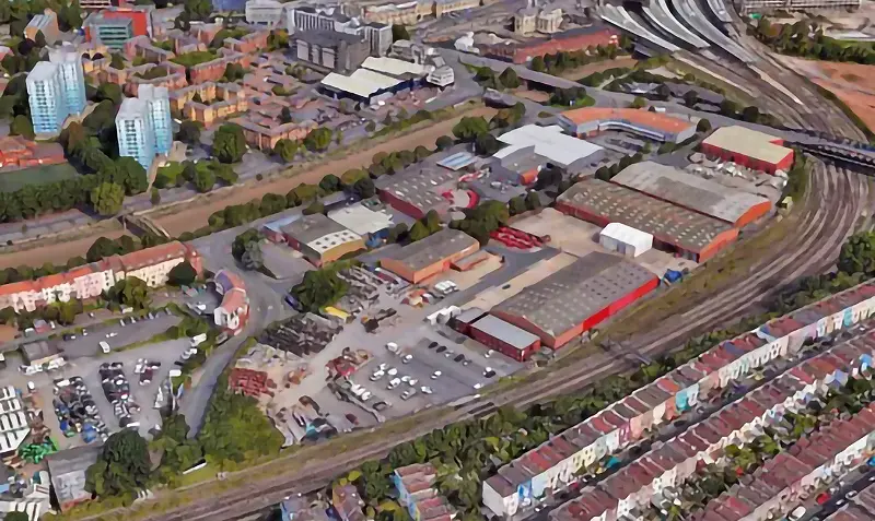
Starting in the 1950s the area between York Road and the railway tracks south of Mead Street has seen heavy redevelopment
Image: Building Homes for Bristol
Starting in the 1950s the area between York Road and the railway tracks south of Mead Street has seen heavy redevelopment, all the houses were demolished and replaced with industrial units. Starting in 2022, new plans have been drawn to replace at least part of the area with hi-rise flats. By the end of 2023, the developers said the would change the way they were going to be built and reduce the number of affordable housing flats.
Weare's, Weir's or Wear's Buildings
There is some confusion, at least for me, about the actual name of this street. It is shown on various maps as Weare's, Weir's or Wear's Buildings. The 1828 Ashfod map shows it as Weare's Buildings; 1885 Ordnance Survey - Wear's Buildings; 1885 Ashford and later maps - Weir's Buildings.
Weare's Buildings were to the southeast of Bedminster Bridge, to the south of York Street and between Stillhouse Lane and Whitehouse Street, parallel to Hope Street.
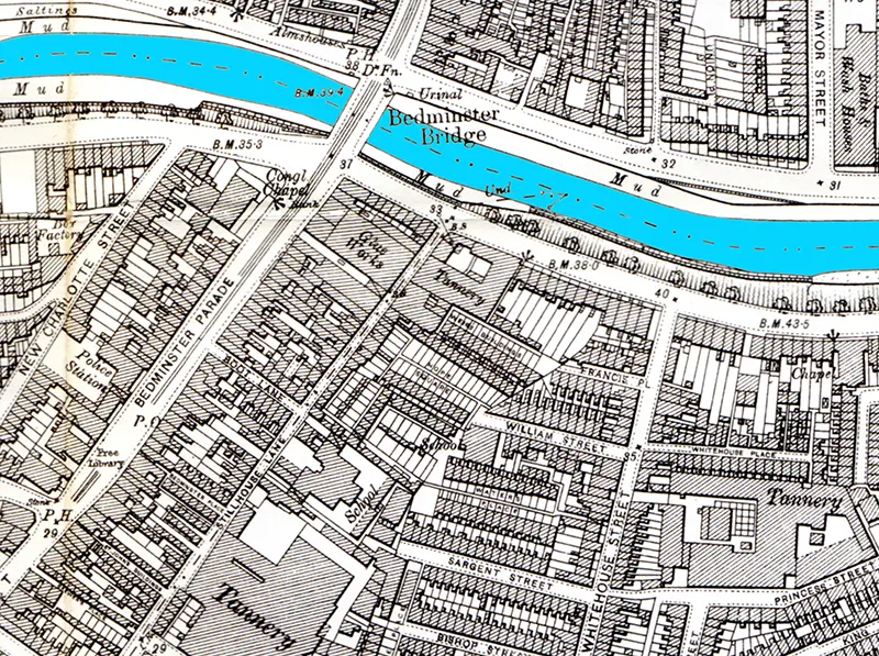
Image: 1902 Ordnance Survey map, Bristol (SW), Gloucestershire Sheet 75.04, reprint by Alan Godfrey Maps
This map shows it as Weir's Buildings
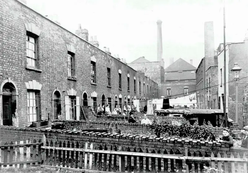
Weare's Buildings, Bedminster
Image: Bristol Archives
Weare's Buildings were two-storey brick houses with pitched pantile roofs, front gardens and small rear yards with outhouses. These were possibly privies although some at the rear of Hope Square had skylights which may instead suggest small workshops. The buildings on Weare Street and Hope Square were demolished around 1933 as part of a slum clearance scheme.
In the 1820s, residents had to go out the front and round the corner into a narrow lane that had a communal lavatory.
The Residents
Weare's Buildings were short, there were only 17 residences.
James Wallis Lavers (1905 - 1994), lived at no. 4, in 1911.
Edward Johnson, a shipwright lived at no. 16 in 1851
Industrial Use
Over the years the area has been subject to several slum clearance and road widening schemes giving industrial archaeologists a chance to examine the area.
The area was known for its tanneries. There were tanneries to the north, east and south of Weare's Buildings. To the west was a glue factory and a brewery. I am old enough to remember when the Courage's brewery opposite Castle Green and the tannery in Coronation Road were in full production and this must have been a particularly smelly part of Bristol.
The brewery was constructed sometime between 1828 and 1883. It was demolished to make way for the glue factory which was constructed in 1904. Most of the site is now covered by housing.
The glue factory was owned by Bristol Manufacturers Ltd. In early twentieth century trade directories, they were described as glue and gelatine manufacturers, grease refiners and hair merchants. Opposite the Stillhouse Lane side of the glue factory was a tannery owned by William Perry and Sons. It's very likely that the two companies were working in partnership with each other especially as waste products from tan yards were an important source of additional income.
Gelatine was obtained from animal hides and bones whilst hair could be used for mattresses. Glues were made from animal hides, hooves, and other parts that had been reduced to jelly, then dried. The jelly was then ground into power or flakes, remixed with water and heated gently in a glue pot to form a brown, brittle glue that was not waterproof. This was the only type of glue available until World War I. The two sites came under the same ownership around 1923 The buildings were linked by the overhead walkway which had the name Bristol Manufacturers written on it as well as by the crane gantry. The company occupied the premises in York Road until about 1970 or a little before.
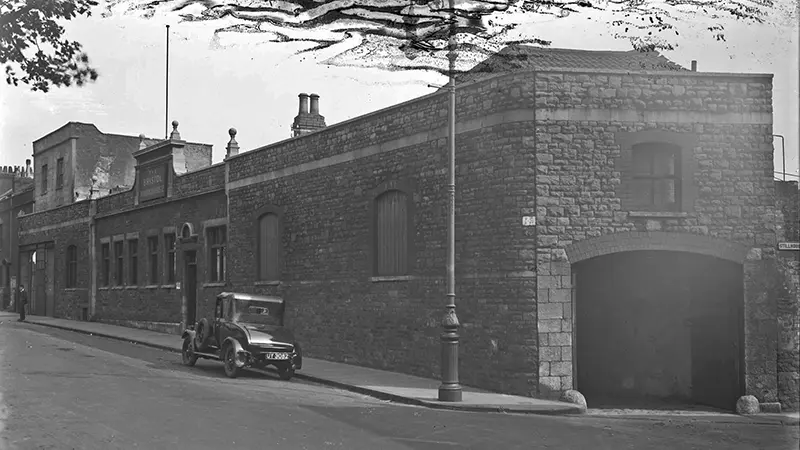
Bristol Manufacturers Ltd. glue factory, York Road, Bedminster, Bristol. The view is taken looking eastwards along York Road towards Bath Bridge. The large doorway on the right would have been one of the entrances into the tannery yard.
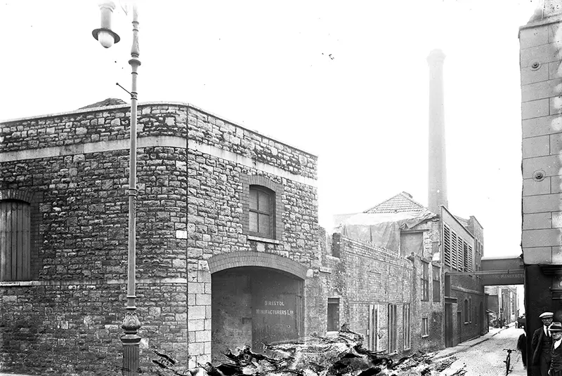
Bristol Manufacturers Ltd. glue factory, York Road, Bedminster, Bristol. The view is along Stillhouse Lane. The former tannery buildings are on the left and the original part of the glue factory would have been on the right.
The northwest tannery had been there since at least 1828 and in 1841 was owned by Robert Hassell. The tannery was closed in 1907 and was replaced by the expanding glue factory, which itself was demolished around 1968. In 2002, excavation of the site of the site found the remains of eighteenth- and nineteenth-century houses around Squire's Court. Also found was the base of a pottery kiln and glass-manufacturing waste, including green and black glass, moils (the excess glass from glassblowing) and crucible fragments, dating to the eighteenth century.
Nostalgia
There's always a nostalgia for these old photos, the one of Weare Buildings from the Bristol Archives has been posted several times in different Facebook groups. There's nearly always someone who says that they should have been kept and at least modernised.
My thought was that if they were designated as slums in the 1930s they must have been awful to live in.
At the end of The Great War in 1918, the city realized something had to be done about the homes and started the renovation of the old and building new across the city. By the 1930s building had started on the new estates at Knowle and Southmead, and later on the one in Hartcliffe.
Bristol Ideas has a lot of information about what was happening from then until the end of WWII...
Bristol Housing Report 1930 (Part 1)
Bristol Housing Report 1930 (part 2)
English City: A Vision of Bristol in 1945
Sources & Resources
8 fascinating photos of how Bedminster has changed over the decades (Bristol World)
1901 census look up - Phillips, Bristol (RootsChat)
Addresses in UK wills 1931-1939 (Toms Wills)
Alfred Oliver (abt. 1834 - 1914) (WikiTree)
Bristol Potters and Potteries (Bristol Potters and Potteries)
Barton Hill History Group (Facebook)
Bristol City Council map site
British Queen (Lost Pubs Project)
British Queen, 53 Weare street, Bath bridge, Bristol, Gloucestershire (PubWiki)
Building homes for Bristol (Bristol Mayor)
Bumstead History
Chappell Allen & Co. Ltd., Bristol (Bristol Archive)
Chappell Allen & Co. Ltd., Bristol (Bristol Archive)
Greater Bristol by Laurence Cowen writing as Lesser Columbus, 1893
James Wallis Lavers (Nathan's Genealogy)
Jonas Harper (Mitchell Families Online)
Landmark Bristol housing development could switch to 'modular' and be less affordable (Bristol Post)
Mary Elizabeth Shute (Bath Record Office)
New Inn (Bristol's Lost Pubs - Internet Archive)
Robert Henry Houghton (Wyndham March)
Ropewalk (Wikipedia)
Royal Victoria Hospital and Military Cemetery at Netley
Silas A'Court about 1809 North Cadbury (British Genealogy)
South Bristol's Death Toll at Passchendaele South Bristol Voice, Bedminster, September 2017
Supplement to the New Zealand Gazette Thursday, May 11, 1899
The 1930s Slum Clearance in Bedminster (Bristol and Avon Archaeological Society)
The Criminal Activities of Gladys Violet Nutt (1907) Bristol (Tracing Ghosts)
The Neck family of Newton Abbot, Lambeth, Newport, Bridgwater and Bristol, England (Boddyparts)
The Skidmore and Scudamore Families of Frampton Cotterell, Gloucestershire, 1650-1915 (Skidmore Family History)
Thomas Wheaton (bc1702-1779) & Sarah Godfrey (Wheaton Wood)
Weare's Buildings, Bedminster (Bristol Archives)
Weirs Buildings, Bedminster (RootsChat)
Wilson (RootsChat)
York Gate, Bedminster, Bristol (Farland Developments)